Image: Western Cape APRS Image (Click on image for larger view.)
Mossel Bay now has its own Private Search & Rescue-, Weather- and Disaster Network/System installed and activated. The network will be expanded later to include various areas of the Southern Cape.
The Network/System is based on the Automatic Packet Reporting System (APRS) for real time tactical digital communications of information of immediate value in the local area of Mossel Bay. In addition, all such data is ingested into the APRS Internet System (APRS-IS) and distributed globally for ubiquitous and immediate access. Along with messages, alerts, announcements and bulletins, the most visible aspect of APRS is its map display. Object or information can be placed on the map, and it is distributed to all maps of all users in the local RF network or monitoring the area via the Internet or Search and Rescue Network. Any station, radio or object that has an attached GPS is automatically tracked. Other prominent map features are weather stations, alerts and objects and other map-related volunteer activities including Search and Rescue, Disaster Information and signal direction finding.
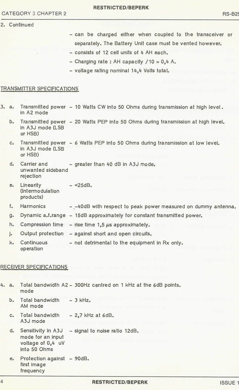
APRS (Automatic Packet Reporting System), is a digital communications protocol for exchanging information among a large number of stations covering a large (local) area, often referred to as "ey-pers". As a multi-user data network, it is quite different from conventional packet radio. Rather than using connected data streams where stations connect to each other and packets are acknowledged and retransmitted if lost, APRS operates entirely in an unconnected broadcast fashion, using unnumbered AX.25 frames. APRS packets are transmitted for all other stations to hear and use. Packet repeaters, called digipeaters, form the backbone of the APRS system, and use store and forward technology to retransmit packets. All stations operate on the same radio channel, and packets move through the network from digipeater to digipeater, propagating outward from their point of origin. All stations within radio range of each digipeater receive the packet. At each digipeater, the packet path is changed. The packet will only be repeated through a certain number of digipeaters -or hops- depending upon the all important "PATH" setting. Digipeaters keep track of the packets they forward for a period of time, thus preventing duplicate packets from being retransmitted. This keeps packets from circulating in endless loops inside the ad-hoc network. Eventually most packets are heard by an APRS Internet Gateway, called an IGate, and the packets are routed on to the Internet APRS backbone (where duplicate packets heard by other IGates are discarded) for display or analysis by other users connected to an APRS-IS server, or on a website designed for the purpose. While it would seem that using unconnected and unnumbered packets without acknowledgment and retransmission on a shared and sometimes congested channel would result in poor reliability due to a packet being lost, this is not the case due to the fact that the packets are transmitted (broadcast) to everyone, and multiplied many times over by each digipeater. This means that all digipeaters and stations in range get a copy, and then proceed to broadcast it to all other digipeaters and stations within their range. The end result is that packets are multiplied more than they are lost. Therefore, packets can sometimes be heard some distance from the originating station. Packets can be digipeated tens of kilometers or even hundreds of kilometers depending on the height and range of the digipeaters in the area. When a packet is transmitted, it is duplicated many times as it radiates out, taking all available paths simultaneously, until the number of "hops" allowed by the path setting is consumed. APRS contains a number of packet types including position/object/item, status, messages, queries, weather reports and telemetry. The position/object/item packets contain the latitude and longitude, and a symbol to be displayed on the map, and have many optional fields for altitude, course, speed, radiated power, antenna height above average terrain, antenna gain, and voice operating frequency. Positions of fixed stations are configured in the APRS software. Moving stations (portable or mobile) automatically derive their position information from a GPS receiver connected to the APRS equipment. The map display uses these fields to plot communication range of all participants and facilitate the ability to contact users during both routine and emergency situations. Each position/object/item packet can use any of several hundred different symbols. Position/objects/items can also contain weather information or can be any number of dozens of standardised weather symbols.
Each symbol on an APRS map can display many attributes discriminated either by colour or other technique. These attributes are:
Moving or fixed
Dead-Reckoned or old
Message capable or not
Station, object or item
Own object/item or other station object/item
Emergency, priority, or special
In its simplest implementation, APRS is used to transmit real-time data, information and reports of the exact location of a person or object via a data signal sent over amateur radio frequencies. In addition to real-time position reporting capabilities using attached Global Positioning System receivers, APRS is also capable of transmitting a wide variety of data, including weather reports, short text messages, radio direction finding bearings, telemetry data, short e-mail messages (send only) and storm forecasts. Once transmitted, these reports can be combined with a computer and mapping software to show the transmitted data superimposed with great precision upon a map display. While the map plotting is the most visible feature of APRS, the text messaging capabilities and local information distribution capabilities combined with the robust network should not be overlooked; Parts of South Africa has a network of APRS stations to allow text messaging between stations in the event of the failure of conventional communications.
APRS is not a vehicle tracking system. It is a two-way tactical real-time digital communications system between all assets in a network sharing information about everything going on in the local area. It means if something is happening now, or there is information that could be valuable to you, then it should show up on your APRS computer, cellphone and VHF radio in your vehicle.

Image: Southern Cape APRS Image. (Click on image for larger view.)
Enough of the technical detail....what does the Mossel Bay network look
like and how does it function. Currently I have setup a Internet
Gateway (IGATE) and Digipeater (Digi) in Heiderand, Mossel Bay with the
ID of ZS1I-10 . The Mossel Bay Internet Gateway (ZS1I-10) relay all
South African APRS data (RF and Internet APRS Backbone) to and from the
host server (APRS-ZA hosted by Hennie ZS6EY) in Johannesburg.

The Mossel Bay Igate and Digi consists of the following equipment:
1. 1 x Laptop Computer (Local Server)
2. 1 x Desktop Computer (Gateway and Digi computer)
3. ZS1I Soundcard Interface
4. 1 x AEA Packratt PK232 Modem (HF + VHF Radio ports.)
5. Uiview Software
6. SARTrack Software
7. 1 x Radius Motorola VHF Radio (144.800 Mhz)
8. 1 x Kenwood HF Radio (Connecting to HF Igates if the Internet is down.)
There are several websites that display information from APRS-IS in real time, the best being aprs.fi


The maps shown above is embedded from aprs.fi. It shows a view of the Mossel Bay Area. As it is a live map, what you will see will depend on when you are looking at it, but during the daytime there are usually at least a couple of mobiles driving around (shown by a red car symbol) whose positions are shown on the map. You can also see digipeaters and gateways, shown by a black or green icon. The red dots on a vehicle's track are the waypoints that were transmitted by the radios in the vehicles. If you point at the dots with your mouse, a line will be drawn connecting the waypoint with the gateway that received it and sent the report to APRS-IS.
The symbol WX in a blue circle is a weather station. Click on these and you will see the latest weather report. Some of the weather stations are operated by radio amateurs, and may use RF to send their data to the system. Others are not. They use APRS but report over a separate network and are never transmitted on RF. When viewing coastal locations at aprs.fi you may also see the positions of ships, which are also reported via their own network.
Other symbols you may see on the map are generated by amateur APRS users using their client software. You might see a repeater, shown by a blue antenna tower symbol. Some amateur - perhaps a repeater group member - has taken the initiative to create that object.
To view APRS activity in the Southern Cape and other parts of South Africa do the following:
There are many ways to get involved with APRS. You need a amateur radio license to transmit any information on APRS. However if you just want to follow (receive) stations and objects you can use APRS FI for this purpose.
There are several APRS software packages. For many years the most popular program for Windows PCs was one called UI-View. However, that program has not been developed for many years as its author G4IDE died a few years ago. It is time for something new and I chose a program called SARTrack. (Search and Rescue Radio Tracking) The International BETA version is now available, and it is FREE!
Now with many different Maps (available off-line after initial download) including Topographical and satellite maps and Canada Toporama, all amateur radio APRS functions, and many extra SAR features, including an advanced Operations Log with 3 differerent displays.
SARTrack is based on an ‘un-docked’ window system, that is, all windows are separate, and can be moved anywhere independently. The primary reason for this design was to enable the use of multi-monitor systems, in particular the use of a video projector displaying the Map, while other windows could stay on the laptop screen.
A single small Main Menu window from which all primary windows can be started stays on-top at all times.
Each window has its own basic settings, which means the User will not be subjected to a main window overloaded with settings and icons, which is unfortunately becoming very common.
For example, the Map window will have most settings needed for that window, while the SAR Log window will only have settings required for that window.
All effort has been made to made to keep the program as easy to use as possible, while only showing the user only what he or she needs to see.
When the original New Zealand version became an International version, intended for both Search and Rescue and Amateur Radio operators, an option was added in the main Setup to switch between SAR and HAM operation.
When SAR is selected, the SAR Log system becomes available, and various other settings in the program appear or disappear.
SARTrack now makes heavily use of OSM (OpenStreetMap) compatible Online servers for the Maps. These maps, based on a system of small Map Tiles, can then be saved for off-line use during SAR operations in the field. This off-line use saving of Tiles is not allowed when using Google Maps or other commercial Map systems.
As of February 2013 SARTrack has the following basic features:
- A primary Map window for all OSM-compatible and Local Maps, with many Maps including Topographical maps for Canada and the USA, and Topographical maps for the rest of the world.
- Transparent Overlays are possible, and a User configurable file for OSM servers is included.
- A Google Map window which can be synched with the primary map (but on-line only)
- A New Zealand Topographical off-line Map system (3 Gigabyte download required)
- A full APRS system, including an advanced APRS Message system, Stations, Objects, etc.
- Selectable overlays on the Maps, like Map outlines, Grid, Radio-Range, etc.
- Warning when Stations (Trackers) time out, and warnings when Priority beacons (from Trackers) are received.
- A Replay system, which makes it possible to replay an entire day of a SAR Operation, including the Tracks, Messages and the SAR Log, with a timer window showing when it all happened.
- The SAR Log can be exported in a delimited form.
- There are many more features in the program, to discover it all, download and install the software, if is free.
SARTrack is completely stand-alone, runs on Windows 2000 and higher, does not use any libraries, does not use .NET, does not use the Windows Registry, does not load any things on Windows start-up.
Updates will be checked for once a day, only when SARTrack is started.
These where the original requirements when we started in 2006 and most are implemented:
- To be able to track up to many stations, and to display them on a topographical map.
- All Map data to be locally available on the laptop (no Internet required).
- Every station (tracker) to get a Tactical callsign, separate colour track, Icon, customizable Screen label.
- Screen Labels to show (selectable): Tactical callsign, Coordinates, Speed, Altitude, Course
- Screen Labels to change color if the station has timed out, or has send a Priority message.
- Warning systems to show stations loss of signal, and Priority Warning with screen and Audio signal and selectable Message.
- A Priority Icon to show on the map when priority signal received. Also automatic log entry.
- Event Log (Running Log) system, which enables the operators to enter Log entries with pull-down lists for all active stations. Automatic Log entry in case of Priority Signal received, or loss of signal, and when Icon Markers are added by the operators. The Log can be added to from multiple computers, both locally and remote. The Radio operator can enter Log entries which will then show up on the Controller PC, and any other PC's active on the search.
- Option to print out Log entries and messages on the local printer (on an entry-by-entry basis).
- Capability for operators to add special Marker Icons on the map, with detailed data attached to it, including documents and pictures.
- Capability to draw search areas on the map and share with other computers.
- Dual Screen capability, where the Map screen can be displayed on a separate monitor or video projector, while all operational displays are on the laptop screen.
- Capability to network several computers and share all data, so a radio operator can enter Log entries and view location of stations, and the operations team view the map and operate another laptop in the operations room.
- Capability to connect to an Igate server via the Internet, if available, to share all Tracking data with computers across South Africa.
- A messaging system which enable all computers to communicate encrypted text messages with each other, even if only connected by radio.
- A 'Text Message' system which enables Radio based computers to send one-line emails and TXT messages to mobile phones.
- All data, tracking information, events, log entries etc. to be stored immediately and permanently on all connected computers.
- Capability to re-play the entire Search on the screen.
- To print out the Log system and tracking maps at the end of the search.
Furthermore, the program must be
- Extremely easy to use, following all standard Windows conventions, such as dragging the Map by left-mouse down and drag, zooming in and out with the mouse-wheel, right-clicking on Icons on the screen and get a pop-up menu with all options, etc.
- As many functions as possible should be automated.
- No requirement to use the more advanced functions; the program should work and start tracking right after startup.
At the time of writing (Updated February 2013), most of the above functions have now been incorporated in the program, and the program is at Beta level.
The way Land Search and Rescue has worked, and it still working, is based on paper maps, the compass, and in later years, radios and even portable GPS units. Search teams take a topographical map with them, and on a regular basis need to stop, try to find their own position on the map, using compass, local features, and then radio his information back to the operations center. Lately, some teams carry portable GPS units with them, but they then have to try to extract the right digits and transmit these back to base over the hand held radio.
At the operations center, the radio operator writes this down, and passes it on to the controller, who then has to locate the position on their own paper map, and mark it. This system is extremely tedious, time consuming, clogs up the radio channel, and prone to error.
Now imagine a system where the location of all search teams shows up live on a computer screen, or a video projection, overlaid on a digital topographical map. Not only the team's current location, but with multi coloured tracks, an arrow in which direction the team travels, and a label with additional information like altitude, speed and the coordinates in either 'GPS' or SA Grid format. Not only the position of the teams in the terrain is clear, but also the relative position to each other can be seen with a single glance at the screen.
A search area can be drawn on the screen, and special Icons, with detailed information attached, can be added. It is immediately clear if areas have been covered, or missed in the search. If a team finds a person, or if they run into trouble themselves, they can trigger a Priority Message, which will cause an visual and audio alarm to go off, and a special Priority Icon will show up on the screen at that location. Other teams can then immediately be dispatched to that location, and directions can be given to them by the controller, who can see, live, where all teams are. If a team takes off in the wrong direction, or into the wrong valley, this can be immediately corrected by the controller. So, this system works exactly opposite as the current situation. It is not a question that the teams try to give their location to the controller.
The controller knows where the teams are, and he can tell the teams where they are, and where he/she wants them to go, which is the way it should be. As described on the Software page, many other features are available in the SARTrack program, all especially designed for SAR use. Other tracking systems There are other tracking systems available, based on a satellite link, or a cellular connection. These systems work well for the purpose for which they are designed. Systems designed to work over the cellular network, only work when you have cellular coverage. This is often not the case in many search areas, and especially not when teams disappear in dense forest of deep gullies or valleys. It is unsuitable for SAR use.
There are two basic satellite tracking systems. One uses a Geo-stationary satellite. This satellite is in a 40,000 Km orbit above the earth, at a 'fixed' position. Any object between the tracker and the satellite , including the person's head or body, will cause the signal to be blocked. The other system is the use of either the GlobalStar or Iridium networks. These satellites orbit the earth at several hundred kilometers. While the Tracker units currently available have certainly improved in size and weight, they are in our opinion still not suitable for use by a person walking bush with a backpack.
These units need to have a clear view of the sky to get proper connection to the satellite, any object like trees, and worse deep gullies will cause loss of signal. Even the head or body of the wearer will block the signal. Also, the cost of these systems is high. The Trackers are not cheap, and the operating costs can be high. In the APRS system as we are currently using it, all trackers transmit a location every 30 seconds. This would become very expensive if 15 teams with 15 satellite trackers would be in the field for days at the time. The SARTrack system use is free. Then there is the problem of the downlink.
Almost all satellite tracking systems advertised at the moment, are based on the signal being received somewhere in the world (and not necessarily in South Africa) by a satellite ground station. It then uses the Internet to get the data to a server, owned by the company who sells the trackers. Then, special software running on the user's computer logs onto this server, and then shows the received data on the screen... But only if the end-user has Internet access!
If the forward field base has no Internet connection, the system cannot be used. Satellite trackers can be an excellent choice for vehicles, boats and aircraft, who generally have a clear view of the sky, can use a high-gain antenna and have the battery power to spare. The data will be forwarded to a permanent operations center with permanent Internet access. But for teams tramping in the bush, with often a forward field base also in the bush, these systems are, in our opinion, not suitable. Also, software especially designed with special features for Search and Rescue is not available.
The SARTrack system consists of a case with Trackers, a couple of small portable Digipeaters, and a laptop with a hand held radio attached to it. The whole system can be quickly set up in any remote location, and is completely independent of outside communication systems. If the portable repeaters can access a permanent repeater and get connection with the outside world, more options open up, but it is not required. Okay quite a mouth full but as can be seen this software is in my opinion well suited for a wide variety of uses in the Southern Cape.
In Summary: APRS provides situational awareness to all operators of everything that is going on in his local area, whether it be MSBWX Weather reporting, traveler info, Direction Finding, objects pointing to ECHOlink and IRLP, or Traffic reporting, Disaster- and emergency response. All of this while providing not only instantaneous operator-to-operator keyboard messaging capability for special events, but also an always-on Voice Alert backchannel between mobiles in simplex range. Think of APRS as a signalling channel/news channel to reveal ALL resources and live activities that are in range of the operator at any instant in time.
I would like to invite radio amateurs in the Southern Cape to join the Mossel Bay APRS network on 144.800 Mhz FM and the general public to monitor Mossel Bay APRS activity on APRS.FI.
Updates to follow as and when the Mossel Bay APRS Network is extended and utilized this holiday season.
- MSBWX